New AI tool generates realistic satellite images of future flooding
| dc.contributor.author | Chu, Jennifer | |
| dc.date.accessioned | 2025-05-02T14:45:20Z | |
| dc.date.available | 2025-05-02T14:45:20Z | |
| dc.date.issued | 2024-11-25 | |
| dc.identifier.uri | https://hdl.handle.net/1721.1/159227 | |
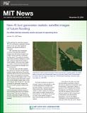
| dc.description.abstract | A generative AI model visualizes how floods in Texas would look like in satellite imagery. | en_US |
| dc.language.iso | en_US | en_US |
| dc.publisher | MIT News | en_US |
| dc.subject | LLSC | en_US |
| dc.subject | AI | en_US |
| dc.title | New AI tool generates realistic satellite images of future flooding | en_US |
| dc.type | Article | en_US |
| dc.identifier.citation | Chu, J. (2024, November 25). New AI tool generates realistic satellite images of future flooding. MIT News. https://news.mit.edu/2024/new-ai-tool-generates-realistic-satellite-images-future-flooding-1125 | en_US |
Files in this item
This item appears in the following Collection(s)
-
LLSC Information
Information about the MIT Lincoln Laboratory Supercomputing Center